Western Idaho, between seven devils, the Gospel hump, and Frank Church Wilderness
Lower Salmon River Map: Rapids, Four Canyons & the Route to the Snake River
The Lower Salmon rafting route begins at Hammer Creek in western Idaho and follows the river through Green, Cougar, Snowhole, and Blue Canyons before the Salmon joins the Snake River. From there, the trip continues downstream to Heller Bar.
The map below follows that route mile by mile, marking the major rapids, canyon sections, side streams, historic sites, and other landmarks that help you understand how the trip unfolds. It includes many of the places you may encounter along the way, but not every rapid, camp, or possible stop.
Quick Facts: Lower Salmon River
- Begins: Hammer Creek
- Canyons: Green, Cougar, Snowhole, Blue
- Rapids: Class II to III
- Ends at: Heller Bar, Snake River
- Season: July through August
- Trip Length:
5 days, 74 river miles
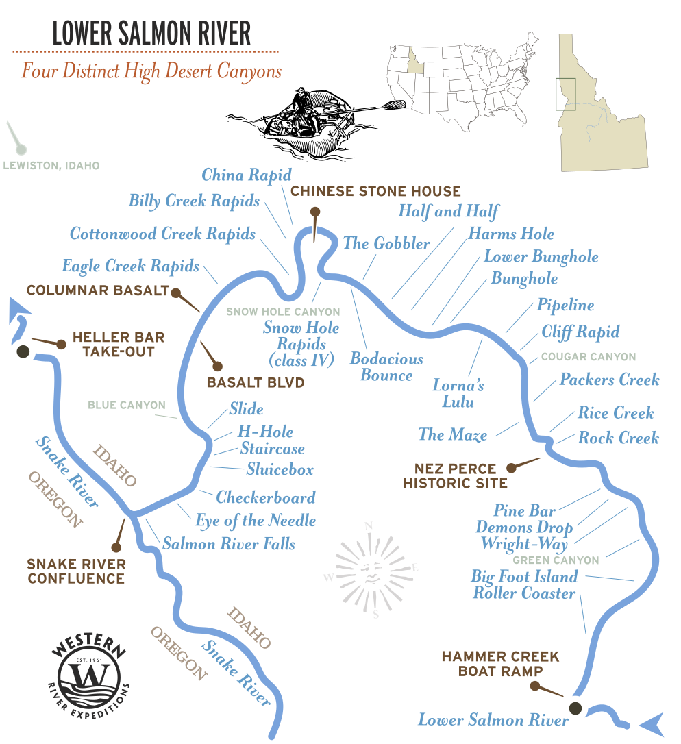
Lower Salmon River Map
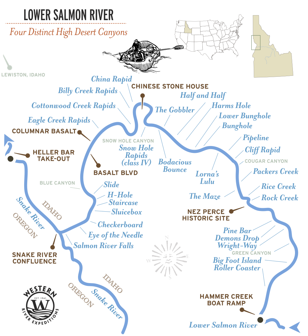
Lower Salmon 5-Day Route
The journey begins at Hammer Creek on the Salmon River and finishes at Heller Bar on the Snake, making the Lower Salmon the only Western River Idaho trip that ends on a different river than it begins. Along the way, you'll travel through four distinct canyons—Green, Cougar, Snowhole, and Blue—each with its own character but all connected by the same broad, free-flowing river.
Most of the trip's biggest rapids arrive early. Slide Rapid, at river mile 3.9, is the one guides watch most closely because it changes dramatically with water levels. Eagle Creek follows at mile 12.8, and after that the river settles into a gentler rhythm, with long pools, sandy beaches, and plenty of opportunities to swim, explore, and relax between rapids.
Near the end of the trip, the Salmon meets the Snake River. The final miles flow on the larger Snake to Heller Bar, where the expedition ends—but only after carrying you from one of America's most famous rivers onto another.
At a glance:
74 river miles, Class II to III, 5 days, four canyons, Hammer Creek to Heller Bar.
Trips:
Lower Salmon 5-Day
Lower Salmon Rapids by Mile
The Lower Salmon uses the International Scale of River Difficulty, Class I to V. This run is Class II to III, which is why it is the Salmon trip Western River points families and first-timers toward in Idaho.
The Salmon is free-flowing. No dam upstream means the river runs on snowmelt, and by July and August, when this trip runs, it has settled into its warm, friendly summer character.
| RIVER MILE | RAPID | CLASS | WHAT IT IS |
|---|---|---|---|
| Mile 0.5 | Roller Coaster | II | Long set of fun waves |
| Mile 26.8 | Bodacious Bounce | III | Fun wave train - straightforward in higher flows |
| Mile 29.6 | Snowhole Rapid | III-IV | Treacherous in high flows, entertaining challenge for guides |
| Mile 34.2 | China Rapid | III-IV | Several large boulders, longer rapid |
| Mile 39.6 | Eagle Creek Rapid | III | Nice waves to hit, some holes to avoid. |
| Mile 49.7 | Slide Rapid | I-IV | Classic illustration of high vs. low flow differences |
| Mile 50-52 | H-Hole, Sluicebox, Checkerboard, Eye of the Needle | III | Series of fun rapids as canyon narrows |
The Four Canyons
The Lower Salmon doesn't pass through one long canyon; it threads together four distinct canyons in succession: Green, Cougar, Snowhole, and Blue. Each has its own geology, scenery, and landmarks, but together they form a continuous 74-mile wilderness corridor between Hammer Creek and the Snake River. As you follow the map downstream, these canyon names become natural milestones, marking the river's progression toward its final confluence. Looking at the map you can almost distinguish each canyon by the groupings of rapids as you follow the route.
| CANYON | WHAT IT IS |
|---|---|
| GREEN CANYON | The first, and where the Class III drops cluster: Wright Way, Demon's Drop, and Pine Creek |
| COUGAR CANYON | Mostly Class II rapids, narrows toward entrance to Snowhole. |
| SNOWHOLE CANYON | Narrower, steeper walls than previous canyons. Rock outcroppings more prominent. |
| BLUE CANYON | Similar to Snowhole , but steeper and rockier walls. |
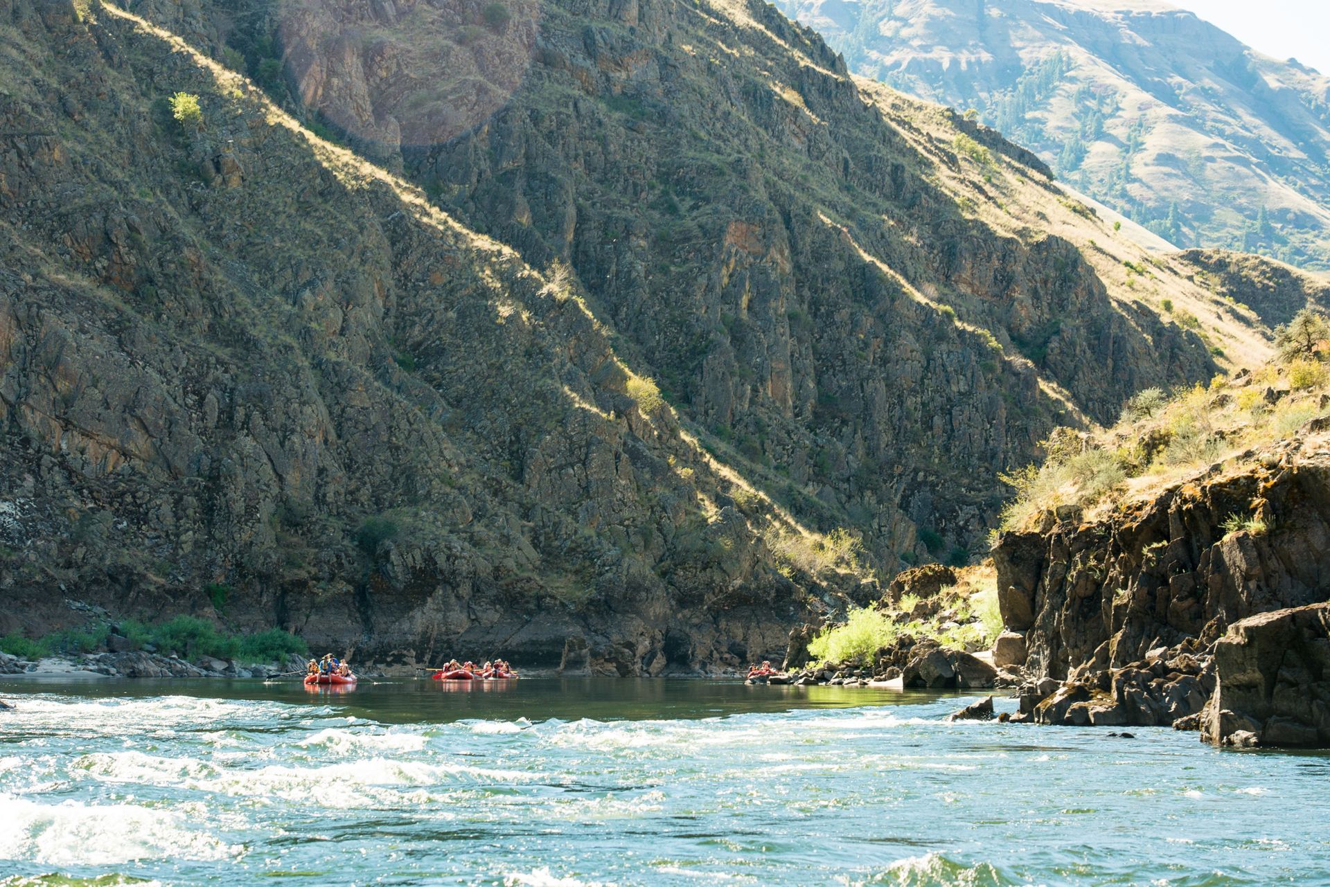
Where the Salmon Meets the Snake
One of the most unusual things about the Lower Salmon is that the trip ends on a different river than it begins. At the Salmon and Snake River confluence, the Salmon River ends and the final miles continue downstream on the Snake to Heller Bar. It's one of the few rafting trips where you finish on an entirely different river than the one you launched on.
Adventure with confidence
Frequently Asked Questions
Where does the Lower Salmon begin and end?
The Lower Salmon rafting trip begins at Hammer Creek, where the Main Salmon leaves Idaho's central mountains, and follows 74 river miles to Heller Bar. Along the way, the Salmon flows through four named canyons before ending at its confluence with the Snake River. Trip continues downstream on the Snake River to the take-out at Heller Bar.
How hard are the Lower Salmon rapids?
Class II to III, which makes it the gentlest of all three Salmon River trips Western River offers. The rapids come early, Slide at mile 3.9 and Eagle Creek at mile 12.8, and the rest of the run is warm water, long floats, and beaches.
Why does the trip end on the Snake River?
One of the Lower Salmon's most unusual features is that it finishes on a different river than it starts. At the Salmon and Snake River confluence, the Salmon River officially ends. Rafters continue the last few miles on the larger Snake River before taking out at Heller Bar.
Is the Lower Salmon good for families and first-timers?
It is one of the best family and first-timers river adventures that Western points our guests to. Class II to III water, warm enough to swim, big sandy beaches for camp, and children as young as five are welcome from mid-July.
What are the four canyons on the Lower Salmon?
The Lower Salmon passes through four consecutive canyons: Green Canyon, Cougar Canyon, Snowhole Canyon, and Blue Canyon. Together they form a continuous 74-mile wilderness corridor between Hammer Creek and the Snake River. Each canyon has its own landmarks, tributaries, and history, but all are connected by the same free-flowing river.
How do the Middle Fork, Main, and Lower Salmon differ?
The Middle Fork is the wilderness whitewater run: 100 miles, 100 rapids, Class III to V. The Main Salmon is the big-water classic, 82 miles, Class II to IV. The Lower Salmon is the gentlest and the warmest, 74 miles through four canyons.
What river mile is Slide Rapid?
Slide Rapid is located at approximately river mile 3.9 from Hammer Creek, making it one of the first major rapids on the trip. Because it arrives early and changes significantly with water level, it is the rapid guides watch most closely each season.
Where can I find a more detailed Lower Salmon river map?
For a mile-by-mile guide to rapids, camps, side hikes, natural history, and points of interest, Western River's Lower Salmon River Guide provides a much more detailed reference than the overview map shown here. It's designed for guests who want to better understand the river before or after their trip. Request one using the free trip catalog section at the bottom of this page.
Still curious to learn more? Give us a call.
Waterproof Lower Salmon Map
For a map you can take down the river, we recommend the waterproof guidebooks, sold in the Western River store.
Plan Your Lower Salmon Trip
Five days on the Lower Salmon, with warm water, playful rapids, and sandy beaches for swimming and relaxing. Family Magic departures add special activities for kids.
- Begins: Lewiston, ID
- Best for: Families & sunshine
- Rapids: 56 Class II-III
- Ages: July 1-15 10+ Jul/Aug 5+
Request Your Free Trip Catalog
Explore our complete collection of rafting adventures across the Grand Canyon, Utah, Idaho and Oregon. This full-color catalog includes detailed trip overviews, sample itineraries, maps and planning guidance to help you compare destinations and choose the experience that's right for you.