Green River, Eastern Utah
Desolation Canyon River Map: Green River, Utah
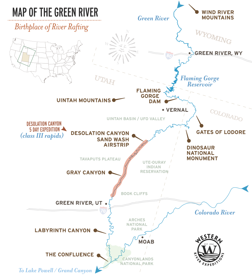
The Green River runs more than 700 miles, from its source at Fremont Lake in Wyoming's Wind River Range to the Confluence, where it meets the Colorado River deep inside Canyonlands National Park. Along the way, it passes through Flaming Gorge, the Uinta Basin, and eastern Utah's canyon country, cutting some of the most remote river corridors in the American West. Two of the most stunning and remote sections the Green River carves through are Desolation Canyon and Gray Canyon.
The map below shows the whole river, every named section, and the stretch that Western River runs: Desolation and Gray Canyon from the Sand Wash put-in to the Swasey's Landing take-out. To many, it is the most spectacular rafting section on the Green, a canyon that in places is deeper than the Grand Canyon, with more than 60 named rapids, large beaches during much of the season, and several great hikes for deeper exploration.
Quick Facts: Desolation & Gray Canyon
- Miles: Desolation Canyon and Gray Canyon cover 84 river miles from Sand Wash to Swasey's Landing
- Rapids: More than 60 named, almost all Class I to III
- Popular Season: May through August
- Minimum Age: Ages 5 and up
Sections of the Green River
The Green is a long river, and people search for "the Green River map" meaning very different stretches of it. Here is the whole river in downstream order, with the section Western River runs called out.
| SECTION | WHERE | WHAT IT IS |
|---|---|---|
| FLAMING GORGE | Utah / Wyoming line | Reservoir and tailwater below Flaming Gorge Dam. Calm-water floating and fishing |
| GATES OF LODORE | Dinosaur National Monument, Colorado | The Green's famous whitewater canyon bending from Colorado back into Utah |
| SPLIT MOUNTAIN | Dinosaur National Monument | Short steep canyon section below Lodore |
| UINTA BASIN | Northeast Utah | Open flat country where the river slows between canyons |
| DESOLATION CANYON ★ | Tavaputs Plateau, eastern Utah | The section Western River runs. 84 miles of remote canyon, 60+ rapids, Fremont rock art, no roads |
| GRAY CANYON ★ | Below Desolation | Where the Desolation run finishes. The canyon opens out and the river eases toward Swasey's Landing |
| LABYRINTH CANYON | Below Green River, Utah | Calm/flat water stretch winding toward Canyonlands popular with canoes |
| STILLWATER CANYON | Canyonlands National Park | The final flat water run to the Confluence with the Colorado River |
Green River Map: Desolation and Gray Canyon
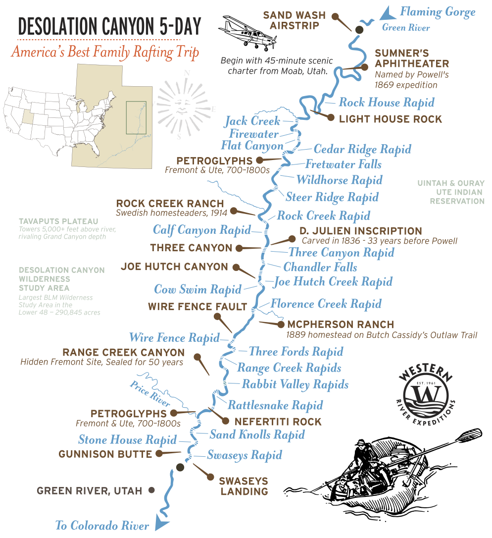
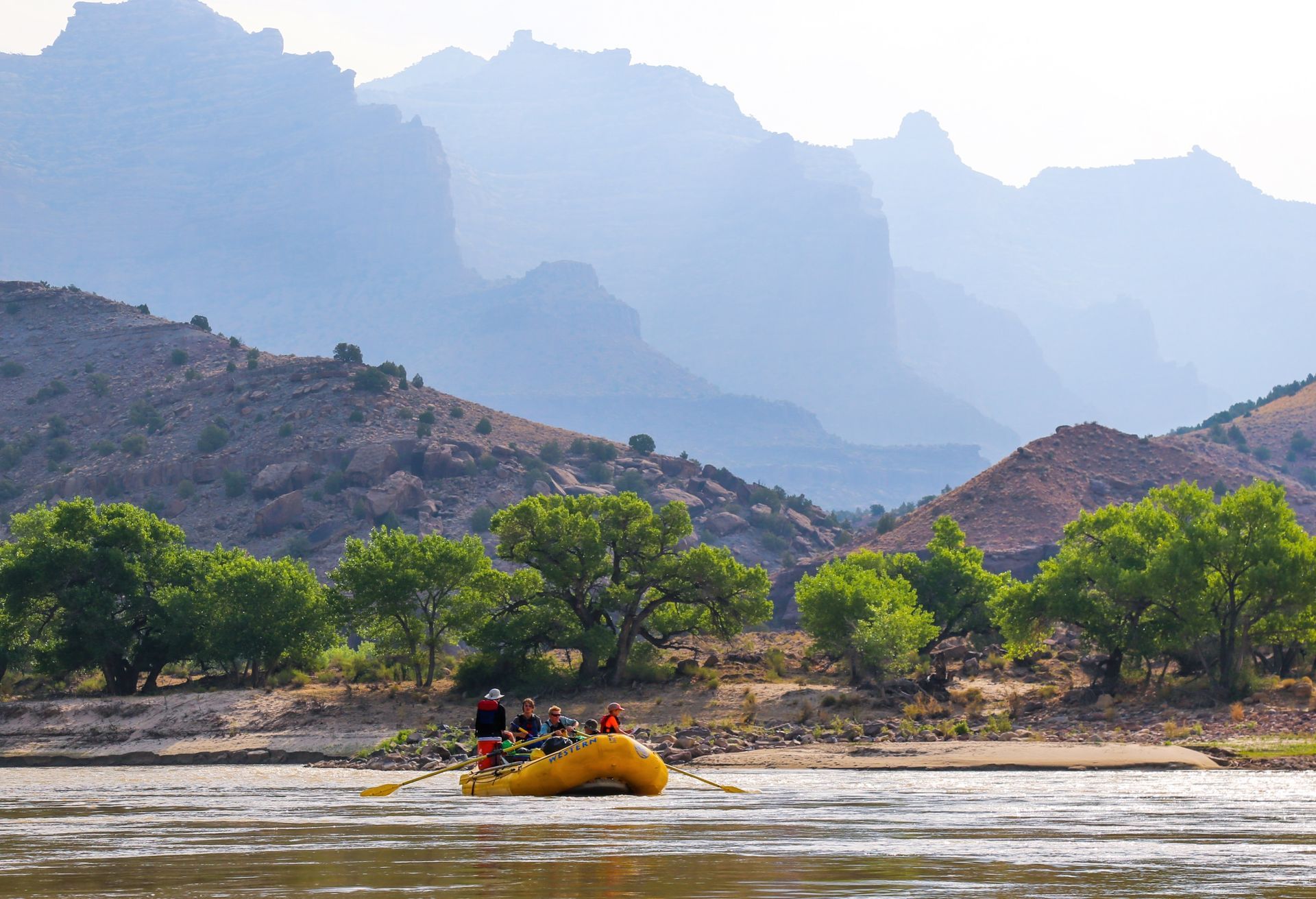
Desolation Canyon is the stretch that makes the Green worth flying into. The river cuts down through the Tavaputs Plateau and the canyon walls climb as it goes, until the rim stands more than a mile above the water in places. There is no highway to the bottom, no cell signal, and virtually no one else on the river.
The whitewater builds as you go. The upper canyon is mostly riffles and quick, splashy waves. The named rapids cluster in the lower canyon, where Wire Fence, Three Fords, and Coal Creek arrive in close succession on Day 4. Then the walls step back, Gray Canyon opens up, and the river carries you out to Swasey's Landing.
At a glance: 84 river miles, more than 60 rapids, Class I to III, scenic flight in and drive out.
Trips:
Desolation Canyon 5-Day
Explore DESOLATION
Canyon in
360°
Desolation and Gray Canyon Rapids by Mile
Desolation's rapids are rated on the
International Scale of River Difficulty, Class I to V. This is not the Grand Canyon's 1-to-10 scale, and the difference matters: Desolation tops out at Class III, which is why it is the trip Western River points
families and
first-time rafters toward. Ratings shift with water level, and the Green is free-flowing below Flaming Gorge Dam, so the river runs highest with spring snowmelt and mellows through the summer.
| RIVER MILE | RAPID | CLASS | WHERE |
|---|---|---|---|
| 39.5 | Steer Ridge | III | Upper canyon. One of the longer rapids up top, winding past several rock piles |
| 55 | Joe Hutch | III | Lower canyon. Energetic and bouncy, as the river builds toward its biggest water |
| 59 | Wire Fence | III | Lower canyon, Day 4. Long, fast, and read-and-run. Often underestimated |
| 59.5 | Three Fords | III | Lower canyon, Day 4. The marquee rapid. The most complex on the river at low water, a solid III at high flows |
| 70 | Coal Creek | III | Lower canyon, Day 4. A long, read-and-run finale before Gray Canyon opens |
Side Canyons, Rock Art, and River Landmarks
Some of the best moments on the Green River happen after the boats pull to shore. Desolation Canyon holds one of the richest concentrations of Fremont rock art on any western river, along with homestead ruins and side canyons that only open up from the water.
| RIVER MILE | PLACE | WHAT IT IS |
|---|---|---|
| 34 | Fremont Petroglyphs | Rock art panels left by the Fremont people, reachable on short walks from the river |
| 41.8 | Rock Creek Ranch | A historic homestead on the river, a green pocket in the middle of the canyon |
| 0 | Sand Wash | The put-in. Where the scenic flight lands and the river trip begins |
| 84 | Swasey's Landing | The take-out, below Gray Canyon |
How You Reach the River
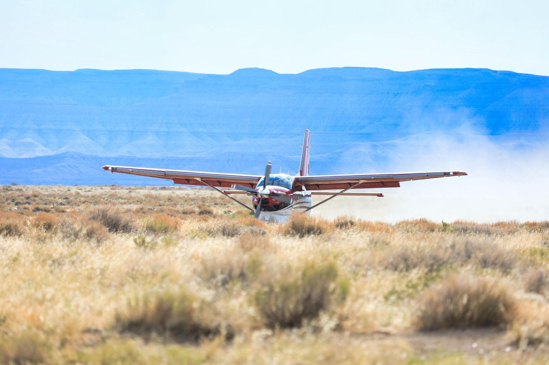
Getting to Desolation is part of what makes it feel remote. The trip begins in Moab with a scenic flight over the canyon country to the Sand Wash put-in, which is the only practical way in. From the air, you see the Tavaputs Plateau and the canyon you are about to explore for the next five days.
From Sand Wash, the trip runs 84 miles downstream through Desolation and Gray Canyon over five days and four nights, camping on sandy beaches along the way. It finishes at Swasey's Landing, below Gray Canyon, where the road reaches the river again and the shuttle returns you to
Moab, Utah.
Why Desolation Canyon Runs So Deep and So Quiet
The Green River did not carve Desolation by cutting into a mountain range. Like so many other magnificent canyons in the area, the river cut down through the Tavaputs Plateau while the plateau itself was rising. The result is a canyon that in places is deeper than the Grand Canyon, yet almost nobody outside the river community knows it exists.
Unlike the Colorado through the Grand Canyon, the Green here is largely free-flowing. Below Flaming Gorge Dam the river runs on snowmelt, so it comes up high and fast in late spring and settles through the summer. The rapids change character with it: bigger and pushier at high water, more technical as the rock bars surface later in the season.
John Wesley Powell led the first recorded expedition down the Green in 1869 and named this stretch the Canyon of Desolation, for what he did not find in it: no people, no settlement, no sign that the outside world had ever arrived. More than 150 years later, that is still close to true.
The canyon is managed by the
Bureau of Land Management, which administers the river permits for the run.
Get a Waterproof Green River Map Guidebook
For a map you can actually take down the river, we recommend a waterproof mile-by-mile river guide to the Green through Desolation and Gray Canyon, available in the Western River store. Guests mark the rock art panels and side canyons they explored and the camps they slept in, and bring it back on the next trip to fill in what they missed.
Adventure with confidence
Frequently Asked Questions
Where does the Green River start and end?
The Green River begins at Fremont Lake in Wyoming's Wind River Range and runs more than 700 miles south and west, ending where it meets the Colorado River at the Confluence, inside Canyonlands National Park in Utah.
How long is the Green River, and how much of it does Western River raft?
The river runs more than 700 miles in total. Western River's Desolation and Gray Canyon trip covers 84 river miles from the Sand Wash put-in to the Swasey's Landing take-out on a five-day trip.
How many rapids does Desolation Canyon have, and how hard are they?
More than 60 named rapids, almost all Class I to III on the International scale. Desolation tops out at Class III, which makes it Western River's most family-friendly multi-day trip. Children as young as five are welcome.
What are the other sections of the Green River?
Moving downstream: Flaming Gorge, the Gates of Lodore and Split Mountain in Dinosaur National Monument, the open Uinta Basin, then Desolation and Gray Canyon, and finally Labyrinth and Stillwater Canyon down to the Confluence. Desolation and Gray is the section Western River runs.
How do you get to Desolation Canyon? Is it really that remote?
There is no road to the canyon floor. Trips begin with a scenic flight from Moab to the Sand Wash put-in, and finish at Swasey's Landing where the road meets the river. In between there is no highway, no cell signal, and no way out but downstream.
Is there a printable or waterproof Green River map?
We recommend a waterproof mile-by-mile river guide to Desolation and Gray Canyon, available in the Western River store, which is what river runners actually carry on the water.
Still curious to learn more? Contact us.
Plan Your Desolation Canyon Trip
Ready to see Desolation Canyon from the Green River? It's the best stretch of the whole river.
The Green River through ancient, winding canyons, milder rapids, broad sandy beaches, rich history, and a stunning scenic flight to the river's edge.
- Begins: Moab, Utah
- Best for: Families
- Rapids: 60+ Class I-III
- Ages: 5+
Request Your Free Trip Catalog
Explore our complete collection of rafting adventures across the Grand Canyon, Utah, Idaho and Oregon. This full-color catalog includes detailed trip overviews, sample itineraries, maps and planning guidance to help you compare destinations and choose the experience that's right for you.