Pointed and pronounced, Diamond Peak reaches 3,512 feet high. The approach to the summit consists of sharp bands of unreliable limestone, making reaching the top very difficult. To the west of Diamond Peak flows Diamond Creek.
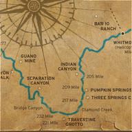
The Diamond Creek road beginning in Peach Springs, Arizona is the first place a vehicle can access the canyon at river level since Lee’s Ferry at mile 0. River trips often choose to end here, and some river trips begin here running the last 50 miles of Grand Canyon and most of the Lower Gorge. During summer monsoons, Diamond Creek often floods washing away portions of the road. In 1984, a big flood washed two separate trucks, both loaded with an entire river trip’s worth of gear, into the river and Diamond Creek Rapid. Most fortunately, moments before the flood arrived, everyone who had been riding in the trucks escaped to high ground.
Joseph Christmas Ives named Diamond Creek on his overland exploration to the area in 1858. John S. Newberry, the first professional geologist to witness the canyon’s grandeur, traveled with Ives. Ives and company were the first whites on record to reach the depths of Grand Canyon.
A U.S. backed topographic expedition, led by Lieutenant George Wheeler, reached Diamond Creek in the fall of 1871. The group, with help from Native Americans; rowed, poled, and dragged three boats up 200 miles of the Colorado River, including the boulder and rapid strew Lower Gorge. It took Wheeler and his men 33 days to reach Diamond Creek, and five days to return to Camp Mojave.
This comprehensive PDF guides include river maps, overview, full itineraries, camping and weather information, details on physical requirements, packing lists and more.