GRAND CANYON, ARIZONA
Grand Canyon River Map
The Colorado River travels 277 miles through the Grand Canyon, from Lees Ferry to the western end of the canyon near Lake Mead. The river passes through towering canyon walls, major whitewater, hidden side canyons, waterfalls, historic sites, and places accessible only from the river.
The Grand Canyon overview map below shows the entire river corridor and how Western River’s Grand Canyon trips fit together. Western River runs the upper 188 miles, from Lees Ferry to Whitmore Wash, on its 6 and 7-day trips, and 92 miles of the lower canyon, from Whitmore Wash to Pearce Ferry, on its 3 and 4-day trips.
The Grand Canyon river section maps take a closer look at the major rapids, side canyons, landmarks, and access points along each river section. They are not intended to show every rapid or possible stop, but rather some of the many incredible places you may see during your expedition.
Quick Facts: Grand Canyon River Corridor
- Length: 277 river miles, Lees Ferry to Lake Mead
- Western River runs: Upper 188 miles (6 and 7-day trips) and lower canyon (3 and 4-day trips)
- Rapids: About 160 named, 42 rated 5 or higher on the canyon's own 1-to-10 scale
- Biggest rapid: Lava Falls, mile 179.8, rated 9-10
- Season:
April through mid-September
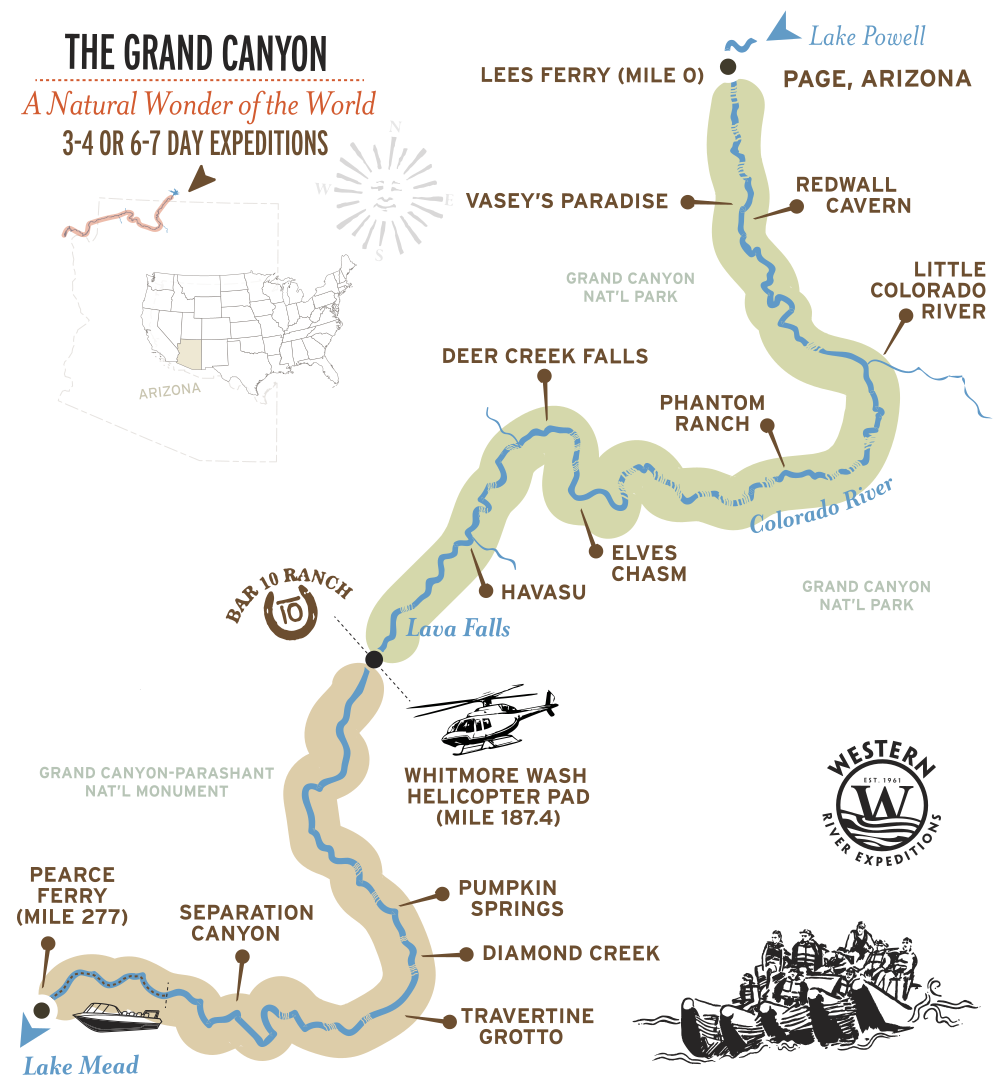
Grand Canyon River Map by Trip
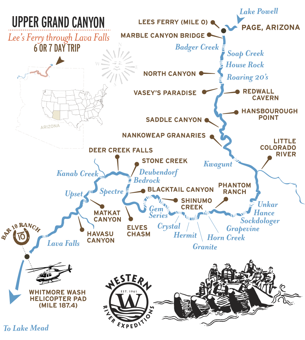
Upper Canyon: 6 and 7-Day Trips
The upper Grand Canyon gives you 188 miles, roughly 60 rapids, and every major named rapid in the canyon, from
Hance and Sockdolager in the Granite Gorge to
Crystal, Hermit, and the finale at
Lava Falls. The trips launch at
Lees Ferry and run the heart of the canyon, with side-canyon hikes to places reachable only by river, before lifting out by helicopter at
Whitmore Wash.
At a glance:
188 river miles, 60 rapids, helicopter out at Whitmore Wash.
Grand Canyon 6-Day,
Grand Canyon 7-Day.
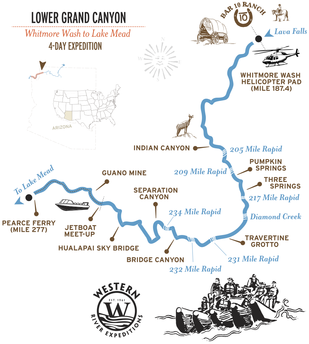
Lower Canyon: 3 and 4-Day Trips
The lower Grand Canyon is the high-impact shorter route. It starts with a helicopter ride into the canyon at
Whitmore Wash, then 92 miles of river through 16 rapids that run Class II to III+, gentler than the upper canyon's big water but set in the same mile-deep walls, ending with a jetboat to Pearce Ferry near Lake Mead. The 4-day trip adds a night at Bar 10 Ranch before the helicopter flight into the canyon.
At a glance:
92 river miles, 16 rapids, helicopter in and jetboat out.
Grand Canyon 3-Day,
Grand Canyon 4-Day River & Ranch.
Explore Grand
Canyon in
360°
Grand Canyon Rapids by Mile
Grand Canyon rapids are rated on the canyon's own 1-to-10 scale, developed by river historian Otis Marston and used by guides ever since. A classification of 1 is flat, moving water; a 10 is the most powerful navigable whitewater in the canyon. Ratings shift with water level, and every rapid creates a different story with each level.
Lava Falls or
Crystal are difficult at any water level and only amplify with more water. For what the numbers mean, see the
Whitewater Rapid Classification Guide. For details on the major rapids, see the
Grand Canyon Rapids Guide.
| RIVER MILE | RAPID | RATING (1-10) |
|---|---|---|
| MILE 77.5 | Hance | 8-10 |
| MILE 79.2 | Sockdolager | 8-9 |
| MILE 90.8 | Horn Creek | 8-10 |
| MILE 94 | Granite | 9 |
| MILE 95.5 | Hermit | 8-9 |
| MILE 98.9 | Crystal | 10+ |
| MILE 179.8 | Lava Falls | 9-10 |
These are only a few of the rapids along the route. The upper canyon includes everything from the early drops of Marble Canyon, such as Badger Creek, Soap Creek, and House Rock to the closely spaced whitewater of the Inner Gorge and major rapids such as
Hance, Horn Creek, Granite, Hermit,
Crystal, and
Lava Falls.
The lower canyon continues below
Whitmore Wash with its own series of rapids and long stretches of remote river.
Side Canyons, Waterfalls, and River Landmarks
Some of the most memorable moments in the Grand Canyon happen after the raft pulls to shore. Side canyons, waterfalls, tributaries, archaeological sites, and natural amphitheaters break up the river journey and reveal places that cannot be seen from the rim. Here are just a few that you might explore on your trip.
| RIVER MILE | PLACE | WHAT IT IS |
|---|---|---|
| MILE 33 | Redwall Cavern | A vast river-cut cave in the limestone wall |
| MILE 52 | Nankoweap Granaries | Ancestral Puebloan granaries set high above the river |
| MILE 61 | Little Colorado River | A turquoise tributary at its confluence with the Colorado |
| MILE 116.5 | Elves Chasm | A travertine grotto and waterfall |
| MILE 136 | Deer Creek Falls | A waterfall pouring straight to the river's edge |
| MILE 156.8 | Havasu Canyon | Turquoise water flowing out of a side canyon into the Colorado |
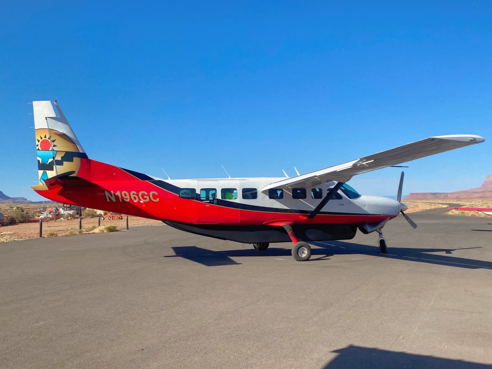
How You Reach the River
One of the unusual things about a Grand Canyon river trip is that simply reaching the river, or leaving it, is part of the experience.
On the 6-day and 7-day trips, guests travel to the Lees Ferry launch area and begin the journey at river mile 0. After 188 miles through the canyon, the trip reaches Whitmore Wash, where a helicopter carries guests from the river to the rim before the return journey.
The
3-day and 4-day trips reverse that sequence. Guests travel from Las Vegas toward Bar 10 Ranch, then descend by helicopter to the
Colorado River at Whitmore Wash. From there, the trip continues 92 miles through the lower canyon before connecting with a jetboat for the final river exit toward Pearce Ferry. The 4-day trip includes an additional night at Bar 10 Ranch before the helicopter descent.
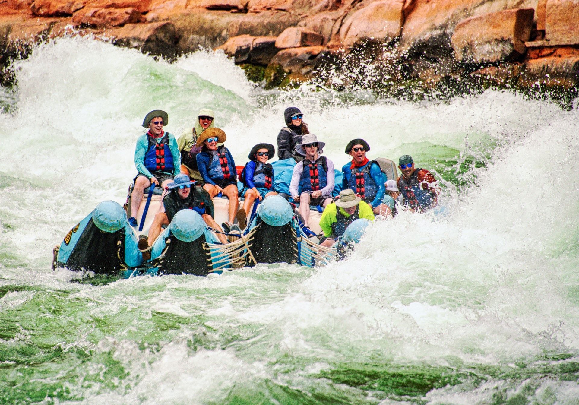
Why the Grand Canyon Has Such Big Whitewater
The biggest rapids in the Grand Canyon are created by more than the Colorado River’s gradient through the canyon. At the mouths of side canyons, flash floods carry boulders, sediment, and debris into the main channel. These debris fans constrict the river, redirect the current, and create many of the canyon’s major rapids.
Because flows below Glen Canyon Dam are regulated, the Grand Canyon does not follow the same simple spring-snowmelt pattern as many free-flowing western rivers. Water releases change throughout the season, and each rapid responds differently as river levels rise and fall.
Get a Waterproof Grand Canyon River Map Guidebook
For a river map to take with you on your Grand Canyon trip, we recommend the waterproof Belknap Grand Canyon river guide, sold in the Western River store. It's the rapid-by-rapid, mile-by-mile guide river runners have used for decades. Guests love to mark the side canyon hikes and waterfalls they explored as well as river camps, often taking it on repeated trips and checking off different areas they experienced each time.
Adventure with confidence
Frequently Asked Questions
How long is the Grand Canyon stretch of the Colorado River?
The Grand Canyon section runs 277+ river miles from Lees Ferry to Lake Mead. Western River runs the upper 188 miles on the 6 and 7-day trips and the lower canyon on the 3 and 4-day trips.
How are Grand Canyon rapids rated?
On the canyon's own 1-to-10 scale, not the standard Class I–V system. Roughly 160 rapids are named, and 42 rate 5 or higher. A rating of 8, 9, or 10 refers to this Grand Canyon scale. See the classification guide for what each number means.
What is the biggest rapid in the Grand Canyon?
Lava Falls, at mile 179.8, rated 9 to 10. It is widely considered the most famous rapid in North America, and it comes near the end of the 6 and 7-day trips.
Which Western River trip covers which part of the map?
The 6 and 7-day trips run the upper canyon, Lees Ferry to Whitmore Wash. The 3 and 4-day trips run the lower canyon, Whitmore Wash to Pearce Ferry near Lake Mead.
How do you get in and out of the canyon?
The upper trips launch by raft at Lees Ferry and helicopter out at Whitmore Wash Helipad. The lower trips helicopter in at Whitmore Wash and jetboat out to Pearce Ferry.
Is there a printable or waterproof Grand Canyon river map?
We recommend the waterproof Belknap Grand Canyon river guide, available in the Western River store. It is the rapid-by-rapid, mile-by-mile guide river runners have used for decades.
Still curious to learn more?
See more common questions or contact us.
Plan Your Grand Canyon Trip
Four ways to experience the Grand Canyon from the river. Find the journey that fits your time and travel style.
Six days in the Grand Canyon. Run Crystal Rapid and Lava Falls, hike hidden side canyons, sleep on beaches no road will ever reach, and helicopter out of the canyon.
- Begins: Las Vegas
- Best for: Rapids & Hiking
- Rapids: 60+ Class III-V
- Ages: 12+
Seven days exploring 188 miles of the Grand Canyon. Run famous rapids, hike hidden side canyons, camp beneath the stars, and helicopter out of the canyon.
- Begins: Las Vegas
- Best for: Extended Vacation
- Rapids: 60+ Class III-V
- Ages: 12+
Helicopter into the Lower Grand Canyon for three days of whitewater, hikes, and desert nights. Then continue downstream by jet boat to Pearce Ferry.
- Begins: Las Vegas
- Best for: Shorter trip
- Rapids: 16 Class II-III
- Ages: 9+
One night at Bar 10 Ranch with horseback riding and cowboy BBQ, then helicopter into the Lower Grand Canyon for three days of whitewater rafting and exploration.
- Begins: Las Vegas
- Best for: River + Ranch
- Rapids: 16 Class II-III
- Ages: 9+
Find the perfect Grand Canyon Expedition
River maps, itineraries, camping details, weather, packing lists, travel logistics, and more, all in one place. Get a complimentary expedition guide for any trip that interests you.